scott e via Flickr


SEJournal Online is the digital news magazine of the Society of Environmental Journalists. Learn more about SEJournal Online, including submission, subscription and advertising information.
July 15, 2014
Special Report on Risk and Resilience: Part Two
By AMY WOLD
 |
 |
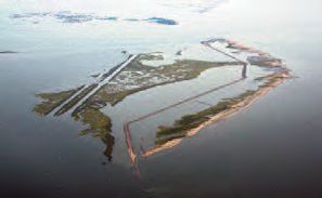
| Lying just to the east of Grand Isle, East Grand Terre Island forms a natural barrier between the Gulf of Mexico and Lower Barataria Bay. The photo above shows how it appeared in 2007 before the start of a $31 million rebuilding program. |
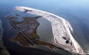
At right, East Grand Terre Island after rebuilding of the 2.8-mile, 620-acre barrier shoreline and marsh. Photos: Louisiana Coastal Protection and Restoration Authority |
If you’re coming to the SEJ annual conference in New Orleans, Sept. 3-7, chances are you’ll hear more than once the phrase “Louisiana loses a football field of land every hour.”
Timeline of Louisiana Coastal Restoration Actions1987: A group of scientists, coastal community members and others known as the Coalition to Restore Coastal Louisiana publishes a report outlining the problem and setting down what needs to be done. A big lesson: Coastal restoration – as the current government structure was set up – wasn’t anyone’s responsibility. 1989: Louisiana passes Act 6, which sets up the Governor’s Office of Coastal Activities and a State Wetlands Authority. It also sets up the Coastal Wetlands Trust Fund, with money coming from state oil and gas money. 1990: Congress passes the Coastal Wetlands Planning, Protection and Restoration Act through the work of then-senators John Breaux and J. Bennett Johnston. It dedicates part of a small-engine fuel tax for use in coastal restoration in Louisiana. This CWPPRA program (pronounced Quip-pra) remained the main dedicated funding for coastal restoration in Louisiana for years. That work, which continues today, ultimately led to the development of the Coast 2050 plan, which was a broad outline for coastal restoration across the state. December 2005: The Louisiana state legislature creates the Coastal Protection and Restoration Authority, or CPRA, to be the single entity to handle coastal restoration and storm protection in the state. 2007: CPRA releases and receives legislative approval for a master plan for coastal restoration and protection. Although general in nature, the plan was hailed as another step forward, while acknowledging more work needed to be done. 2007: The Coast 2050 plan leads to the Louisiana Coastal Area plan being included in the congressional Water Resources Development Act of 2007, which comprises more specific projects for coastal restoration, the latest development in a long list of plans for dealing with land loss. 2012: As required by law, CPRA releases the 2012 master plan. It was specific in laying out projects and areas of focus. For many it was a first look at areas of the coast that weren’t going to see the level of protection or restoration they had come to hope for. |
That’s because it’s a simple way to help people understand the very large scope of what land loss has meant to the state – not only in recent years, but for decades.
This land loss has moved whole populations northward over time, erased place names from National Oceanic and Atmospheric Administration maps and forced residents to adapt to a Gulf of Mexico that keeps getting ever closer.
After Hurricane Katrina in 2005, there were a number of voices in the national press who asked the question, “Why does anyone still live there in harm’s way?” People in coastal Louisiana knew the answer and it’s as complicated as the land loss they are still facing every day.
Louisiana may have hit the national spotlight for a time, but coastal communities elsewhere around the country will have to find their own answers to that same question, even as more and more people move toward the coast — and the water moves ever closer to them.
National implications of land loss in Louisiana
For Louisiana, land loss means the loss of communities, loss of fishing and loss of cultural heritage. But it doesn’t end there.
For the country as a whole, Louisiana land loss means that vital oil and gas production, refining and pipelines are increasingly exposed to tropical storms and hurricanes. It also means that shipping channels, needed to get inland products to countries overseas, are threatened as the Army Corps of Engineers struggles to keep a river open that was ready long ago to change course.
In other words, coastal land loss matters to Louisiana, but it matters just as much to the rest of the nation. It’s just that coastal Louisiana is dealing with those impacts now.
For Louisiana, the answer to the dilemma starts with how the coastal area was built. For thousands of years, the Mississippi River has meandered across this delta, spreading sediment in one area only to change course to add land to another area. These so-called delta splays abandoned by the river would eventually decay, leaving behind barrier islands, as the rest of the coast retreated and another part of the coast was born.
This is the natural way of deltas and it would have continued that way for thousands more years – that is, except for the arrival of people who didn’t want the river to change or flood. Early European settlers created their own personal levees and built their houses high in the area because they knew from experience that they could try to contain the water in its banks, but the river eventually would win.
Then in 1927, a great flood brought devastation to large parts of the country, including Louisiana, and the federal government made a decision that enough was enough. A large levee system along the river was built, essentially constricting the river to its banks. The wandering and the sediment deposition in the wetlands of south Louisiana were largely contained.
The natural regression of old deltas, no longer fed by the Mississippi River mud, began. It was a known consequence accepted for the greater national good for more than a century as witnessed by this comment in an article in National Geographic dating back to December 1897.
“No doubt the great benefit to the present and two or three following generations accruing from a complete system of absolutely protective levees, excluding the flood waters entirely from the great areas of the lower delta country, far outweighs the disadvantages to future generations from the subsidence of the Gulf delta lands below the level of the sea and their gradual abandonment due to this cause. While it would be generally conceded that the present generations should not be selfish, yet it is safe to say that the development of the delta country during the twentieth century by a fully protective levee system, at whatever cost to the riparian states and the Federal Government, will be so remarkable that people of the whole United States can well afford, when the time comes, to build a protective levee against the Gulf waters, as the city of New Orleans has done on a small scale against the sea water of Lake Pontchartrain.”
Hurricanes prompt action, but not restoration for all
 |
|
If restoration of Louisiana's coastal wetlands is to succeed, beach plants like the succulent saltwort (Batis maritima) will be just as important as coastal barrier construction. |
That forecast was largely forgotten for years until the 1970s, when researcher Woody Gagliano and others started looking into coastal issues. What they found was coastal land loss.
But it took years of research, meetings and more and more evident land loss before decision makers started to take action (see sidebar with timeline of legislative action).
Then in 2005, Hurricanes Katrina and Rita devastated coastal Louisiana. Although New Orleans got the bulk of the national media attention as the major metropolitan area laid low by the hurricane, the entire coastline saw devastating damage from the one-two punch. More than one million Louisiana residents were displaced and about 200 square miles of coastal wetlands were lost.
Coastal restoration and storm protection took on a new urgency. But within the decade, as government agencies responded to the threat, it became clear that many areas of the coast weren’t going to see the level of protection or restoration they had come to hope for.
So despite vocal concerns, the Louisiana state legislature in 2012 approved a 50-year, $50 billion master plan. Even if everything in the plan is done, including marsh creation, levee construction, home elevations, river diversions and other water management actions, the plan doesn’t call for a net gain of land until decades into the effort.
While no one will admit defeat, the plan did signal a growing realization that the coastline Louisiana has today will not be the one the state will have in 20, 30 or 40 years.
Response to reality varies by locale
Some adaptation to this reality will be organized by government, but much of the reaction will likely arise spontaneously from the ground up.
 |
|
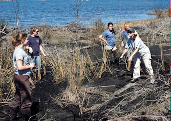
A group of volunteers helping to replant marsh grass on the Bayou Sauvage National Wildlife Refuge east of New Orleans. |
For example, Plaquemines Parish, just south of New Orleans, was hard hit not only by Hurricane Katrina, but several other hurricanes and the Deepwater Horizon oil spill in 2010.
Of the estimated 23,000 people living in the parish, most live in the main city of Belle Chasse, well north of the large areas of the parish that have flooded in the years since 2005.
Parish President Billy Nungesser is hoping the influx of industry and business along the Mississippi River that runs through the entire parish on its way to the sea will help the area rebound. This growth has been enough to convince federal lawmakers to spend money and time to build up the levees in the lower parish, he said. In the meantime, most of the homes seen south of Belle Chasse are either trailers that can be left if a storm approaches, or houses built on artificial hills or perched in the air on stilts.
Just to the west, Lafourche Parish continues to build up its levee around the parish, a system that has not been breached. The levee director, Windell Curole, makes a repeated point that just because the levees haven’t been overtopped, doesn’t mean they won’t be someday.
So why do people live here?
The road through Lafourche Parish is the only one that services Port Fourchon, a major supplier of the needs for offshore oil and gas activity. Although a portion of the road outside the levee system has been elevated, advocates say more work needs to be done since it no longer takes a tropical storm to flood the lower levels of the road with water.
What other coastal communities can learn
There are a number of other reasons that people in other parts of the country should care about land loss in south Louisiana. Seafood production is important here. Hunting and fishing are important here.
But when you come right down to it, oil and gas production, or the lack of it, is something that really grabs the national headlines. It was reported after Katrina that gas prices in some areas of the country went up 40 cents a gallon, which was blamed on production interruption due to the storm.
Will this be the same reason a New York or a Seattle starts to look at adaptation to likely flooding? Probably not. Each coastal area is going to have to find its own answers and reasons to act.
It’s taken decades for Louisiana to come to terms with, study, better understand and adapt to the changes along the coast. But those lessons could help the next coastal community when the sea comes knocking on the door.
Part One: Realities of Coastal Living Often Forgotten, Until the Worst Hits
* From the quarterly newsletter SEJournal, Summer 2014. Each new issue of SEJournal is available to members and subscribers only; find subscription information here or learn how to join SEJ. Past issues are archived for the public here.
SEJ Publication Types:
Topics on the Beat:
Visibility: