Find fellowships, conferences, grants and awards deadlines, workshops and networking opportunities, crowd-sourced leads to job banks, reporting toolkits, hundreds of MOOCs and more. GO >>
Water control structures — dams, locks, weirs, reservoirs, impoundments and levees — are a gold mine of environmental stories. They affect not only the quality of life in human communities, but also the integrity of ecosystems. They matter to people's daily lives: they provide drinking water, electric power for cities and factories, and opportunities for boating, fishing, and swimming. They irrigate farms. They protect people from floods. On the other hand, dam failures from poor construction and maintenance (or just bad weather) have killed more U.S. citizens than terrorism. Just think of the Johnstown Flood, the St. Francis Dam, the Austin Dam, the Buffalo Creek disaster, or the Teton Dam failure.
There is a lot of good data (and bad and missing data) on U.S. dams. That data offers great opportunities (and pitfalls) for data journalism in the environment and energy arena. This presentation offers some resources and ideas for journalists working at the local, regional, and national levels. Dam issues deserve more coverage. This presentation will not try to delve exhaustively into dam issues, but will try to offer some data resources for journalists working on them.
Major Data Sources
National Inventory of Dams
The National Inventory of Dams (NID) contains records on about 84,000 dams in the United States. The NID is maintained by the U.S. Army Corps of Engineers using data from an array of federal, state, and even local agencies. It is authorized by law. It does not include all the dams in the U.S., but includes those meeting certain criteria for size and importance. It is a good resource for reconnoitering major dam issues in your particular area — as well as for getting a broader overview of dam status and safety nationwide.
 The National Inventory of Dams is online and searchable ... up to a point. You must register with the Corps to use it, but registration only requires an e-mail so they know who you are. The online NID can not be downloaded in its entirety or in database format, and online queries produce only limited subsets of the whole database. Moreover, some fields essential to public policy decisions (such as dam hazard ratings) are censored and not available to the public even though the information is in the database. These restrictions are ostensibly for reasons of homeland security, but may instead function to keep the U.S. public from knowing how poor a job various governments are doing to protect the public from dam failures. They also limit the utility of the NID for data journalism.
The SEJ's WatchDog Project has collaborated with IRE's National Institute of Computer-Assisted Reporting (NICAR) to render the NID data in a form more useful to data journalists. We have compiled all the online NID data into a downloadable database format and restored the censored fields from other open sources. This database will soon be published through NICAR's Database Library.
National Performance of Dams Program
The National Performance of Dams Program (NPDP) is run by Stanford University's Department of Civil and Environmental Engineering. Their focus is not merely on data-gathering, but on understanding what can go wrong with dams and how to make it right. Fortunately for dam data geeks, the NPDP maintains a useful set of searchable online databases. They include most dams in the NID. More importantly, they include the dam hazard ratings which the NID censors, so the public has some chance of knowing how big a threat the dams present to life and property. The NPDP also collects data on "dam incidents," which includes many things short of dam failure. It also includes data on the connections of dams to earthquakes. For deeper students of dam safety, the NPDP includes records of dams that no longer exist — whether because of failure or removal. All in all, the NPDP provides an essential supplement to the NID.
The main portal to NPDP's databases is here.
FERC Hydropower Licensing
A fabric of federal laws requires major hydroelectric generating projects to be licensed by the Federal Energy Regulatory Commission (FERC). Typically each major hydro project is associated with a dam or similar structure, and in practice both the dam and the generating facility end up being regulated by FERC. FERC regulates hydro facilities owned by both private electric utilities and public power agencies. FERC also issues exemptions from regulatory requirements to other hydro facilities, typically smaller ones with lower environmental impact. Since most possible major hydro projects in the lower 48 have already been built, the real public policy decisions today more likely involve relicensing of existing plants and the conditions of those licenses.
 Hydropower facilities can be the focus of intense debates over public policy — or merely private and personal economic gain. While hydro is on one level one of the least-polluting forms of power generation, it is also often quite ecologically disruptive. So hydro licenses can generate high-voltage controversy even between and among environmentalists. Hydropower can be thought of as a publicly owned natural resource often licensed to private companies for the economic benefit of their shareholders and ratepayers. Today, hydro licensing can also include pumped storage — an important way of smoothing out peak loads on the electric grid. One good thing about FERC regulation of dams is that the Emergency Action Plans for the dams it regulates at least exist and may be more or less publicly available, even online.
Luckily for data reporters, FERC keeps much of the overview information about these facilities in a set of databases, and these databases are pretty easily accessible. You can download an Excel spreadsheet of all current FERC-licensed hydro facilities here. But equally meaningful is the spreadsheet of FERC-exempted hydro facilities. A good portal page to much of FERC's hydro data and information is here.
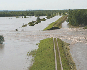
National Levee Database
 The Corps also is building the National Levee Database. The NLD has grown and improved steadily since Congress authorized it in 2007, a short time after catastrophic levee failure inundated post-Katrina New Orleans. The NLD now includes records on over 2,500 levees, a majority of those covered by the Corps of Engineers levee oversight system. But those are just a fraction of all the levees in the United States, most of which have been built and maintained (or not maintained) by state or local agencies.
Despite its still-limited amount of data, the NLD has many cool features that go beyond the NID and offer opportunities for reporting on levee issues. The most important is its openness; it is not censored the way the NID is. The NLD is also better with localized maps, showing legibly what areas are ostensibly protected from flooding by a particular levee. Also essential is its fairly tight integration with maps and data from FEMA's National Flood Insurance Program.
Coal Impoundment Location and Information System (LIS)
 Large impoundments are often associated with coal mining and processing operations in the Appalachian Mountains — formed by dams that may not always be listed, or listed properly, in the NID. The dams are often earthen and have sometimes proven unstable with disastrous consequences. These ponds store coal slurry, a mixture of water and the waste particles removed from coal during processing. When the particles settle, the water is reused for further processing.
After several disasters (most notably the 1972 Buffalo Creek flood and the Martin County spill in 2000), government, industry, and NGOs got together to build a database of coal slurry impoundments — ostensibly for the purpose of improving public awareness of the hazards they may present. There is a story behind this, but a key chapter was the support of the late Sen. Robert Byrd (D-WV), who chaired the Senate Appropriations Committee, and set aside money for the program.
The Coal Impoundment Location and Information System (LIS), started in 2003, is an open, searchable, online database containing about 312 impoundments in West Virginia, Kentucky, Ohio, Pennsylvania, Tennessee, and Wyoming (often several impoundments at one coal facility).
Coal Combustion Residuals Impoundment Database
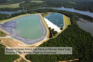
 After the massive spill of coal ash slurry in 2008 from TVA's Kingston Fossil Plant in Tennessee, the incoming Obama administration's EPA vowed to take stronger action to address the hazards some of them present. EPA's first step was data gathering. The eventual result was a fairly complete database of coal-ash (technically "coal combustion residuals," or CCR) impoundments. This database is online and downloadable as a spreadsheet file.This database — and the environmental issues and risks behind it — could be a great starting point for good stories in your locality.
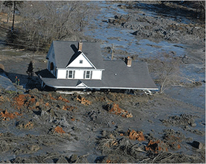
Coal-burning power plants produce vast volumes of waste material. Some of this is "fly ash," the particulates that would otherwise go up the smokestack but are caught by pollution-control equipment. There are lesser volumes of bottom ash, boiler slag, and flue gas desulfurization gypsum. Taken together, they constitute one of the largest waste streams in the U.S., roughly 135 million tons per year. One problem with these wastes is that they contain significant amounts of toxic heavy metals. The ultimate disposal of these materials is a huge, controversial issue that is beyond the scope of this discussion. But before they are disposed of, they are often mixed with water and held in slurry ponds ("coal-ash impoundments"), which at least keep them from blowing all over the place. Because of the difficulties of disposing of coal ash, it is often held in such ponds for long, indefinite periods of time.
Initially, the focus of public attention was on the perceived hazard stemming from possible failure of the dams and levees (typically earthen) impounding these slurries — and the possible impact of spills on people and properties downstream. After initial data-gathering, EPA concluded that some 45 deserved "high" hazard rankings, meaning they posed threats if they failed.
Controversy arose when EPA said it could not publicly disclose the identity of these high-hazard coal-ash impoundments, allegedly for homeland security reasons. It was not EPA that had the concerns; EPA had been told not to disclose the information by the Corps of Engineers and the Department of Homeland Security — two other agencies whose failure to protect the public would become known if the sites were identified. Long story short: after criticism, EPA eventually disclosed all the data and put it online. EPA's effort to regulate coal-ash disposal is still being thwarted by the Obama White House in response to utility industry pressure.
 Catastrophic impoundment failures — while they make for spectacular television — may not be the largest or most likely hazard from coal ash impoundments. The leaching of toxic metals into groundwater is seen as a bigger concern by environmental groups. While government agencies often succeed at distracting the public and the media with terrorist scares, bad engineering, poor maintenance, lack of regulation, and natural flooding are far more likely to cause impoundment failures than shadowy terrorists. Many coal-ash impoundments are located near rivers because power plants are often located near rivers. This means that the ash impoundments may be vulnerable to failure caused by flooding — and that the toxic coal ash might be quickly spread by floodwaters.
Nuclear Plants at Risk for Dam Failure Inundation
The failure of a large dam upstream of a nuclear power plant — however remote the odds — could in the worst case lead to a nuclear disaster on the scale of the one in 2011 at Japan's Fukushima Daiichi plant. This is actually an eventuality that the U.S. Nuclear Regulatory Commission has thought about. Ignoring the rights of the people living near such vulnerable plants, the NRC has chosen not to disclose these hazards to the public.
![]() Fortunately for those nuclear neighbors, various watchdogs have made public lists of plants that could face such risks. The key list was acquired in unredacted form by the environmental group Greenpeace and is now the subject of a lawsuit by Public Employees for Environmental Responsibility (PEER). The list is available in pdf format here. It includes the names of the specific dams and water control structures associated with each potentially vulnerable nuclear site.
Fortunately for those nuclear neighbors, various watchdogs have made public lists of plants that could face such risks. The key list was acquired in unredacted form by the environmental group Greenpeace and is now the subject of a lawsuit by Public Employees for Environmental Responsibility (PEER). The list is available in pdf format here. It includes the names of the specific dams and water control structures associated with each potentially vulnerable nuclear site.
An associated NRC report indicates that the NRC has known for at least a decade that failure of the Jocassee Dam about 10 miles upriver of the Oconee Nuclear Station in South Carolina could overwhelm the plant. While the Oconee plant may be the most egregious example, the NRC identified nearly three dozen other sites where dam failures or flood events could inundate nuclear plants. More information is available in SEJ WatchDogs of August 28, 2013, and October 22, 2012.
Dam Removal Data
Dams are not an unmixed blessing. Despite all the benefits they may bring, many also have a downside. They can prevent fish from swimming upstream to spawn, disrupt river ecosystems in other ways, ruin recreational opportunities for kayakers (even while creating other boating opportunities). Many existing U.S. dams were built long ago — some as much as a century ago. At some dams built for hydropower, the generating facilities have fallen into ruin while the dams remain. Older dams may have stability and safety problems, and their reservoirs eventually fill with silt — degrading their storage capacity and creating a special category of environmental problem.
 For these reasons and more, dam removal projects are a growing trend today — whereas they were rare 15 years ago. So numerous have dam removals become that dam removal databases are now being built. Probably the best is kept by American Rivers, an environmental group that advocates free-flowing rivers. While their database is not online, much of the information in it is. American Rivers has published lists of dams removed in 2012 and previous years in non-database (pdf) form.
State Dam Regulatory Programs and Inventories
Most of the dams in the United States are regulated by state (rather than federal) government agencies, to the extent that they are regulated at all. Some state agencies have good databases of dams within their purview, and some of these databases are even online. If you are pursuing information on dams at a local, state, or regional level, you will want to find the agencies that regulate dams in your area and check in with them. The Association of State Dam Safety Officials maintains a list of agencies and contacts here (click on map to see individual state agencies).
The State of Washington, for example, has published an inventory of dams within Washington, current to June 2013 (although in pdf rather than database format). Likewise, California publishes useful lists of dams within its borders or jurisdiction, in pdf format. But not all states do this.
When dams are inspected for safety or regulatory compliance, these inspections are most often performed by staff of the state engineer's office or state dam regulatory agency. If you want information about the physical condition of dams as it relates to dam safety, it is very often to be found in the results and findings of these inspections. For the most part, these inspection reports and results are not available online. If you are going to get them at all, you will need to ask for them from the state agency — and possibly even request them formally under your state's open records law.
It is a known fact that the National Inventory of Dams collects information about the safety condition of dams — and has done so since at least 2009. According to the Association of State Dam Safety Officials (ASDSO), some 76 percent of the state-regulated high-hazard dams were rated for condition in 2013. Worse yet, at least 15 percent of the high-hazard dams were rated as being in poor or unsatisfactory condition. Yet despite these potential threats to life and property, the National Inventory of Dams censors this information in its publicly available online database. There is no valid homeland security justification for this censorship. Neglecting or ignoring shaky dams that could fail in a major rainstorm is a much bigger risk than terrorism.
Undocumented and Unpermitted Dams
Not all dams are included in the National Inventory of Dams. Moreover, there are many bootleg dams — which have been built even without legally required state permits. Some dams are too small to be included in databases or state dam permit programs — often the case with farm ponds.
One way to find some of these dams is through state dam programs. The State of Washington, for example, launched a major effort in 2008 to inventory unpermitted dams and bring them into the regulatory system. Such efforts are sometimes controversial.
Other Data Sources Relevant to Dams and Levees
Some reporters still automatically distrust Wikepedia as an information source, but it is often no less reliable than other sources, official or unnofficial. (Yes, there are errors in the NID.) We recommend checking everything. But you will find another starting point for researching dam data on Wikipedia's "List of Dams and Reservoirs in the United States." While this information duplicates the NID in some ways and omits things included in the NID, it also includes things not included in the NID — such as data about reservoirs.
The U.S.DA Natural Resources Conservation Service (NRCS) has a database of dams. It appears to be publicly available, although we did not access it for this project. Since the New Deal era, the NRCS and its predecessor agency, the Soil Conservation Service, have given farmers and ranchers financial or technical aid in building typically small-scale earthen dams for farm ponds. Some of these dams are probably too small for inclusion in the NID, although the NRCS database appears to overlap with the NID. The number of NRCS dams is estimated at around 26,000. Metadata and contact information for accessing the NRCS dams database can be found here.
The U.S. Geological Survey offers a wealth of data and information useful to anyone writing about dam and levee issues. Probably the most important is real-time streamflow data coming from the U.S.GS network of streamflow gauges all over the country. Become familiar with your local gauges, because when the downpour starts and your audience asks if the dam will overtop, the crisis may make it harder. U.S.GS does well with geographic (GIS) and mapping data — which may well help you put visual aids on your printed page or web page. U.S.GS also maintains the National Hydrography Dataset — which maps out the hierarchy of tributaries for all U.S. watercourses. If you are a reporter on the go during a flood event, you might want the smartphone app that gives you streamflows.
The Interior Department's U.S. Fish and Wildlife Service maintains the National Wetlands Inventory. If you are writing about dams in relation to flooding or water quality, or even wildlife habitat, the National Wetlands Inventory may help.
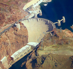
The Interior Department's Bureau of Reclamation is another federal agency (in addition to the Corps) with major responsibilities for building and operating dams. BuRec focuses exclusively on the West, particularly the arid West. Because of long-term shifts in federal funding, its dam-building days are largely over. But it still runs Hoover Dam and a great many others. BuRec has a searchable online Projects and Facilities Database of its dams, but that offers only a little more than the NID itself. It does have information on powerhouses which the NID does not have. Wikipedia also has a list of Bureau of Reclamation dams, with links.
FEMA flood maps are an important resource if you are writing about the flooding aspects of dams and levees, but they are of more use in a graphic way than a hard-data way. When you get down to the neighborhood level, you will find stories. It might be that what you really want are the Corps of Engineers inundation maps, which show what would be endangered in a dam failure — but getting these is like pulling teeth. In the meantime, other inundation maps (slightly different in purpose) may be found from NOAA, NOAA's National Weather Service, or U.S.GS Flood Inundation Mapping.
Believe it or not, dams and impoundments change water quality in important ways, affecting dissolved oxygen, nutrients, and other parameters. Although it is largely beyond the scope of this project, you may want to look at water quality information in data sources like the U.S.GS National Water Information System or the EPA STORET system. The real data crunchers might prefer downloading data from the portal of the National Water Quality Monitoring Council, a joint project of the two agencies.
Some Ideas for Local, Regional, or National Dam Stories
- Which dams in your area or region could threaten lives or property if they failed (look for the high- and significant-hazard dams)?
- Are the dams in your area or region in safe condition? When were the latest inspections and what were the findings? Are they publicly available?
- How many of the risky dams in your area or region have emergency action plans? Get some EAPs, evaluate them, and talk to people about them.
- Are the dam safety and regulation agencies in your area or region conducting good engineering inspections often enough? At all?
- Are the dams in your area or region doing a good job of serving the purposes for which they were built?
- What progress has been made nationally (or locally) in setting emergency action plans for high- and significant-hazard dams over the past decade?
- What is the funding for dam safety in your state or region? What about nationwide? Is this enough to do an adequate job?
- Are any new dams (or locks or other structures) being proposed in your area? Are any existing dams being considered for removal?
- What are the pros and cons of major dams in your area? Whose interests do they help or harm?
- Do your elected representatives get campaign contributions from any of the groups with economic interests in local dams? Do they influence decisions?
- What mitigation measures have been proposed or agreed on for local dams? Have these mitigation measures been carried out? Successfully?
- How will changing weather patterns and water resource needs affect local dams? What are the implications of climate change?
Additional Information Sources
- U.S. Society on Dams
- Association of State Dam Safety Officials
- American Society of Civil Engineers
- FEMA National Dam Safety Program
- National Dam Safety Review Board
- Interagency Committee on Dam Safety
- Federal Energy Regulatory Commission
- National Committee on Levee Safety
- National Association of Flood and Stormwater Management Agencies
- Association of State Floodplain Managers
- FEMA National Flood Insurance Program
Topics on the Beat:
Region:
Library Types:
Visibility: