


SEJournal Online is the digital news magazine of the Society of Environmental Journalists. Learn more about SEJournal Online, including submission, subscription and advertising information.
June 9, 2021

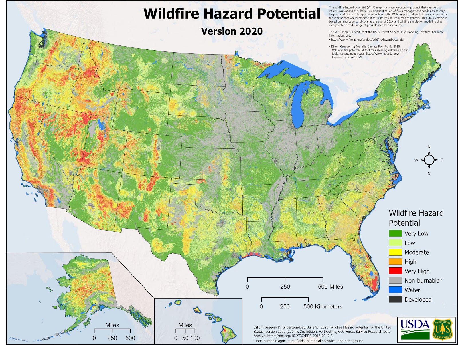 |
| A mapping database from the U.S. Forest Service helps predict wildfire risk. Image: U.S. Forest Service. Click to enlarge. |
Reporter’s Toolbox: Forest Service Offers Mapping Database on Potential Wildfire Hazards
By Joseph A. Davis
As we face accelerating climate change and a wildfire season that is expected to be devastating, you and your audience likely could use more information about wildfire risk.
For environmental journalists, that means precise and granular information about where the risk is highest.
Fortunately, there’s a database for that. Several, actually.
A reminder though: Data is neither magical nor infallible. Your best bet for staying alive (and helping those in your community do the same) is using your eyes and ears, and your common sense. Ground-truth everything. Talk to experts. Stay awake. Imagine the worst and prepare for it.
That said, you’ll find helpful insight in a wildfire hazard potential map and database from the U.S. Forest Service.
Where the data comes from
The Forest Service database was put together at its Rocky Mountain Research Station, better known to its friends as the Missoula Fire Sciences Laboratory. And there they know wildfire (they have smokejumpers on-premises and an airstrip on the backlot).
The data are available in file or map form, free online and downloadable. The resolution is very fine, a 270-meter grid (with an even finer 30-meter resolution available). The current version is for fire year 2020.
It’s based on models, but very smart models using some of the best available real-world information. The model used to create these maps is called the large fire simulator, or FSim, also developed by the Missoula fire lab.
You can even download the software on request, if you are so inclined (that’s not a sport for amateurs). The desktop version is called FlamMap. It is based on another simulation program called ArcFuels10, which is an extension of the commonly used ArcGIS software from ESRI.
How to use the data smartly
As always, it is worth reading the caveats: The data are not really meant for assessing your particular local hazard in real-time, but for mapping out strategic preventive treatment over larger areas. And those maps are impressive.
What is also important is the data fed into the model to come up with predictions of fire risk. This includes things like the amount of fuel, the condition of fuel, drought and other landscape conditions, topography, etc. This is overlaid with map layers showing human structures and populations. FSim updates these variables often.
If you are not a fire-science modeling geek,
you may be more comfortable with a website
called Wildfire Risk to Communities.
If you are not a fire-science modeling geek, you may be more comfortable with a website called Wildfire Risk to Communities, which is interactive, map-based and meant for a more general audience, like community leaders.
It allows you to focus on your particular area of interest and suggests general strategies for reducing wildfire risks to humans and their structures.
A final word to the wise. Don’t use the wildfire hazard potential data in a vacuum. A lot depends on a lot of other things.
First, pay attention to fire weather predictions and warnings for your area from the National Oceanic and Atmospheric Administration’s Storm Prediction Center, the National Weather Service, the U.S. Drought Monitor and the National Interagency Fire Center — as well as state and local agencies.
Then ask whether your community is truly prepared for what could happen.
And for further insight, check out SEJ.org’s environmental issue area resource page on wildfire, which has top SEJournal stories and recent headlines on the topic.
Joseph A. Davis is a freelance writer/editor in Washington, D.C. who has been writing about the environment since 1976. He writes SEJournal Online's TipSheet, Reporter's Toolbox and Issue Backgrounder, as well as compiling SEJ's weekday news headlines service EJToday. Davis also directs SEJ's Freedom of Information Project and writes the WatchDog opinion column and WatchDog Alert.
* From the weekly news magazine SEJournal Online, Vol. 6, No. 23. Content from each new issue of SEJournal Online is available to the public via the SEJournal Online main page. Subscribe to the e-newsletter here. And see past issues of the SEJournal archived here.
SEJ Publication Types:
Topics on the Beat:
Region:
Visibility: