


SEJournal Online is the digital news magazine of the Society of Environmental Journalists. Learn more about SEJournal Online, including submission, subscription and advertising information.
September 15, 2012
Feature
By ROGER ARCHIBALD
Expedition highlights natural corridors at risk
|
|
|
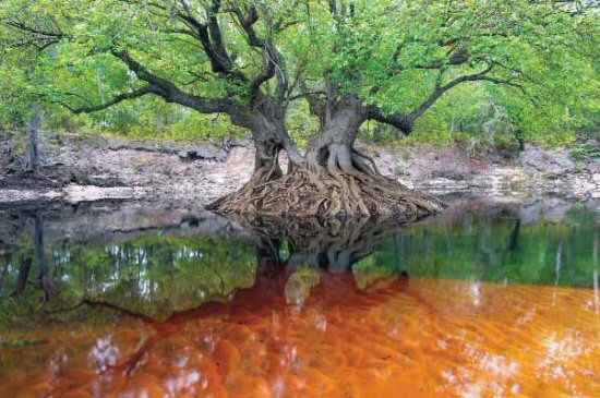
Ascending north Florida’s Suwannee River, the explorers encountered this Ogeechee tupelo tree growing as a separate island in the tannin-stained ‘blackwater’ of the river. PHOTO: © CARLTON WARD, JR. |
| To see all the photos accompanying this article, download the SEJournal Summer/Fall 2012 PDF here (see page 16). |
Their premise was as old as the human impetus to explore. A small band of like-minded individuals sets out into the wilderness intent on reaching a distant destination, and achieving a likely more distant goal.
While images of Kon-Tiki or Lewis and Clark may rush to mind at such a thought, this band wasn’t intent on conquering a vast ocean, or traversing an unknown continent to reach a far shore. Rather than forge a trail through an alien landscape to open the way for future humans to follow, the Florida Wildlife Corridor Expedition sought to do the exact inverse.
This expedition sought to plot a course through the human-forged environment that is present-day Florida in order to reclaim a tenuous natural migratory route that the state’s surviving endemic wildlife might once again follow, as they had unimpeded up until the arrival of European settlement 500 years ago. Consisting of just four members, the team kicked off in mid-January 2012 from the southern-most tip of the Florida peninsula where the Everglades meet the Gulf of Mexico. Over the next hundred days, traveling by kayak, horseback, bicycle and foot, the explorers followed the spring north, threading their way through a thousand miles of the state’s myriad inland landscapes.
After surmounting obstacles both natural and man-made in their efforts to ultimately link the various surviving natural habitats along their convoluted route, they successfully arrived at southeast Georgia’s Okefenokee Swamp in a downpour, but ahead of schedule, on Earth Day, 2012.
Interior Florida a Key to Conservation
The concept for the journey had been years in the making by its principal architect, conservation photographer Carlton Ward, Jr. (an SEJ member since 2001). He had spent his earlier career on six different biodiversity projects with Smithsonian Institution scientists in Africa, where he documented over 400 different species under study, work that led to his first photography book, The Edge of Africa.
An eighth-generation Floridian descended from one of the state’s early ranching families, he was acutely aware of the developmental impact Florida’s population of 19 million was having on its unique natural environment. “Every time I got back from Gabon,” he recalls, “there was another new subdivision on a Florida ranch.”
Following his last African expedition in 2004, Ward made a personal commitment to return to Florida permanently and devote his career to preserving and protecting what remained of the state’s natural and cultural landscapes. With most of its population living on its coasts, he realized “that left large conservation opportunities in the interior.” His first effort to coalesce both his conservation awareness and his professional photography into a proactive organization was the 2004 creation of the Legacy Institute for Nature and Culture “which works to celebrate and protect Florida's natural and cultural heritage through art.”
|
|
|
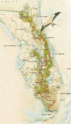
Route of the Florida Wildlife Corridor Expedition. MAP ILLUSTRATION BY MIKE REAGAN. |
Perhaps owing to his own long Florida lineage, the concepts of nature and culture are never separate for Ward. He sees the healthy vitality of established human subcultures dependent on the state’s natural resources — such as Native American communities, coastal fisheries and family ranching — to be every bit as critical to the state’s environmental health as the survival of wildlife and their natural habitats. Florida ranches, in fact, have been a special interest of his, leading to his second photo book in 2009, Florida Cowboys: Keepers of the Last Frontier.
His interest in the upwards of 7 million acres of privately owned ranches in Florida — land that goes relatively unnoticed by the public — led Ward to realize its significance to the survival of the state’s indigenous wildlife. In the course of his ranchland photography, he met Joe Guthrie, a wildlife biologist affiliated with the Archbold Biological Station located west of Lake Okeechobee (Florida’s largest lake, approximately half the size of the state of Rhode Island), who was conducting black bear research on the same properties.
In contrast to some other parts of the country, the collaboration between ranchers and wildlife researchers in Florida has been especially cordial. “Most ranchers are proud of the wildlife on their property,” Guthrie said. “That’s because bears and ranchers depend on the same habitat ... and anything you do to improve bear habitat improves Florida panther habitat as well,” he added, in reference to the state’s signature highly endangered large carnivore. “Carlton caught on to that story.”
(The symbiotic relationship between rancher and researcher was tragically fused in 2008 when Guthrie’s mentor Dave Maehr,a highly respected wildlife biologist from the University of Kentucky who’d done considerable field work in Florida, died in a plane crash during an aerial bear survey. The plane’s pilot, local ranch owner Mason Smoak, was also killed.)
Stringing together natural migratory routes
Ward’s first thoughts about reestablishing natural migratory routes between the various publicly protected tracts of Florida wildlands — from Everglades National Park in the south to Osceola National Forest in the north — were piqued in 2006 by a completely contrary state proposal to construct development corridors in the form of toll roads through some of central Florida’s largest surviving tracts of natural wildlife habitat.
The idea of corresponding wildlife corridors came to mind, and he did a web search for “Florida Wildlife Corridor.” It generated no responses. He subsequently registered that term as an internet URL; it would become the future expedition’s website.
But the concept of wildlife corridors was not new to Florida. Since 1995, Tom Hoctor, director of the Center for Landscape Conservation Planning at the University of Florida, has been working with the state’s Ecological Greenway Network to develop safe passage zones for wildlife to move among adjacent habitats. His work has been especially concerned with specific ‘critical linkages’ in areas experiencing heavy economic development pressure.
In December 2009, both Hoctor and Ward participated in a black bear workshop at the Archbold Station that Guthrie helped organize in the wake of his mentor’s death. It proved to be a seminal event for the creation of the Florida Wildlife Corridor Expedition. During a discussion of the various local wildlife corridors being developed in four different places on the Florida peninsula, Ward asked, “Why can’t we string these all together?”
Up until that point, “we never thought to tie the various critical linkages together into a grand initiative,” Hoctor says.“That was Carlton’s idea.”
Confluence of events, including housing bust, spurred expedition
Between the germ of the Florida Wildlife Corridor idea in late 2009 and the embarkation of the explorers in early 2012, a number of events had to happen to make the expedition feasible, many of them fortuitous. Among them, ironically, was the downturn in the economy and national recession that hit the housing market in Florida especially hard. That event significantly reduced the market forces pressuring private land owners to sell out to development interests.
During the same period, two major federal land management programs designed to protect the vast inland watershed of south Florida’s Everglades were progressing towards fruition. Rather than fall back on public land acquisition to achieve the desired result, these initiatives instead relied heavily on conservation easements obtained from private property owners to keep their land perpetually in its natural state. And given the shambles of the state’s real estate market, conservation easements backed by federal funds suddenly looked a lot more attractive to landowners who might otherwise have contemplated commercial development.
Both programs involve the tributaries of Lake Okeechobee. In July 2010, the Agriculture Department announced the $89 million acquisition of easements to protect 26,000 acres along Fisheating Creek, the only remaining free-flowing waterway draining into the lake, entering from the west.
And in January 2011, the Interior Department announced the creation of the Everglades Headwaters National Wildlife Refuge and Conservation Area, a $700 million effort to protect up to 150,000 acres of the Kissimmee River basin, the lake’s largest tributary, which drains from the north. Two-thirds of that acquisition will occur through conservation easements with private land owners, while the remainder will create the country’s 556th Fish & Wildlife Service unit open to the public.
Considering the timing of the federal initiatives, Ward concluded, “These events worked out perfectly” as precursors to the Florida Wildlife Corridor Expedition which he and Guthrie were then in the midst of planning. “We couldn’t have done this expedition two or three years ago,” he added. “It wouldn’t have been politically possible.”
A bear named M34
One more fortuitous circumstance blessed the planners as they were hard at work developing the expedition’s route — and that was provided by a bear. As part of his research at the Archbold Biological Station, Guthrie had fitted a young male designated M34 with a tracking collar in late 2009. The following May it embarked upon what Guthrie describes as an “extraterritorial sojourn,” essentially a walkabout typical of such bears during the mating season.
Starting near Sebring, M34 headed north to the outskirts of Orlando where he was unsuccessful in crossing Interstate-4, which bisects the state at that point. He then turned west toward Lakeland, before hooking back southeast toward Lake Okeechobee, and eventually returning to roughly where he’d started. All told, M34 ranged over 500 miles through south central Florida in about two months.
The expedition team drew invigorated inspiration from M34’s wanderings. “He filled in the map for us,” Ward said. “He proved the route we were planning wasn’t just theoretical, but actual from the perspective of a black bear ... He painted in our vision for the Florida Wildlife Corridor.” Guthrie was equally effusive in his ursine elation, describing M34 in the expedition’s early blog posts as “the bear whose travels helped galvanize our efforts ... whose movements essentially defined the scale at which this landscape needs to be protected.”
When the expedition finally shoved off in their kayaks last January from the southern-most point on the Florida peninsula near the Flamingo Visitor Center in Everglades National Park, there was an immediate sense of palpable relief that the frenetic pace of preparations was finally behind them. “Now we had to just go do the thing,” Guthrie noted in the expedition blog.
|
|
|
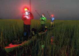
Illuminated by their headlamps, smart phones and the stars above, the expedition team on occasion traveled at night to keep on schedule and avoid the heat of day while traversing the vast sawgrass expanses of the lower Everglades. PHOTO: © CARLTON WARD, JR. |
He and Ward were joined by Elam Stoltzfus, a filmmaker from the Florida panhandle with long experience documenting the state’s natural history, who planned to produce a PBS special, and conservationist Mallory Lykes Dimmitt, a former executive director of the Legacy Institute, who was the team’s most experienced kayaker (though a new position she had just accepted with The Nature Conservancy in Colorado kept her from completing all legs of the journey).
From the moment they embarked, the explorers to a great extent emulated what a wild animal might do if faced with the daunting task of making its way north through interior Florida. By their own motive force, they poled their craft up the vast River of Grass that dominates the Everglades’ confluence with the sea (a journey rarely undertaken by others), occasionally bumping into an unsuspecting alligator. Ahead of them lay challenging highway crossings, the careful negotiation of an Air Force bombing range,and a wildfire that would force them to detour as they neared their ultimate destination.
But on January 18th, as the Florida Wildlife Corridor Expedition moved forward through the sawgrass on its first full day under way, the explorers’ knack for perfect timing remained remarkably intact. Hundreds of miles to the north near Orlando, at one of the Everglade’s many sources, Interior Secretary Ken Salazar officially accepted the first donation of land to create the Everglades Headwaters National Wildlife Refuge and Conservation Area.
- To see all the photos accompanying this article, members only can download the SEJournal Summer/Fall 2012 PDF here (see page 16).
Roger Archibald is the photo editor of SEJournal.
* From the quarterly newsletter SEJournal, Summer/Fall 2012. Each new issue of SEJournal is available to members and subscribers only; find subscription information here or learn how to join SEJ. Past issues are archived for the public here.
SEJ Publication Types:
Topics on the Beat:
Visibility:

