


SEJournal Online is the digital news magazine of the Society of Environmental Journalists. Learn more about SEJournal Online, including submission, subscription and advertising information.
July 9, 2014
By Amy Wold, Reporter, The (Baton Rouge) Advocate
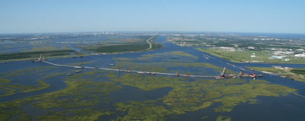 |
| This photo shows the Inner Harbor Navigation Canal Surge Barrier, part of the risk reduction system of New Orleans. Courtesy U.S. Army Corps of Engineers, 2010 |
From 1970 until 2010, 34.8 million more people decided to move towards the coast of the United States and that population is expected to grow just as sea-level rise and climate change continue to increase the risk of living there.
Top sources for background on this topic from the National Oceanic and Atmospheric Administration of the US Department of Commerce:
- U.S. Population Living at the Coast
- State of the Coast
- Coastal resilience guide
- Coastal vulnerability (includes map)
- Hazards of living on the coast
Change and adaptation
For some areas, the changing landscape means elevating homes while in others levees and wetland restoration are seen as being able to mitigate at least part of the risk of living on the coast. Climate change predictions for the southeast United States indicate that these concerns and impacts will only continue to grow with time.
The U.S. Global Change Research Program came out with a report in April that outlines more specifics on what the Southeast and Caribbean can expect as climate change continues.
There are a host of reports and papers on climate change and its potential impacts, as well as adaptation tool kits for coastal communities here at the Southern Climate Impacts Planning Program.
The cost of not adapting to changing conditions has been laid out in a number of papers. One from Entergy Corporation and American's Wetlands Foundation estimates that economic losses from tropical storms along the Gulf Coast will increase by 50 to 65 percent by 2030. The report goes into the cost-effectiveness of preparing for relative sea-level rise and taking adaptive and proactive steps now. There are a number of graphs, maps and pull-out numbers throughout the report that are useful.
One of the adaptive steps some areas are taking involves building large, hard structures like levees and floodwalls meant to hold back the sea. These protective measures raise their own issues.
In the wake of Hurricane Katrina, a number of reports looked at why New Orleans flooded. They include reports from the Corps' Interagency Performance Evaluation Task Force, an American Society of Civil Engineers panel, and an Independent Levee Investigation Team. Links to all those reports can be found here.
In the greater New Orleans area, the federal government decided that $14 billion worth of levee, floodwall, and storm barrier improvements would be built as part of the Greater New Orleans Hurricane and Storm Damage Risk Reduction System.
Before Hurricanes Katrina and Rita in 2005, it was common in Louisiana to refer to levees that stood between the Gulf of Mexico and communities as "flood protection" levees. In the post-2005 world, however, at least the Corps of Engineers has started calling them "risk-reduction" systems in an attempt to help the general public understand there's no guarantee that a tropical storm won't overwhelm a system.
It's arguable how successful that effort has been or how many people living in the city acknowledge they live in a coastal city.
Locks and floodgates
In other areas of the coast such as Lafourche Parish and Terrebonne Parish, communities know about coastal flooding risks from repeated firsthand experience — not only during the 2005 hurricane season, but in following years such as 2008, when they underwent hurricanes Gustav and Ike. In some areas, even high tides with a south wind can bring enough water inland to force floodgates to be closed in order to protect inland communities.
An Army Corps of Engineers report on a lock evaluation for Lafourche Parish says, "The floodgate is being closed more frequently and for longer durations than originally projected in the studies leading to the authorization of the hurricane protection project. The increase in the closure time can be attributed to the combined effects of more active storm seasons in southeast Louisiana and the effects of sea level rise and ground subsidence."
The report examines a proposal for changing a floodgate into a lock in order to allow navigation access to and from Port Fourchon, an important hub that services a large part of the Gulf of Mexico oil and gas operations. Find the full report here.
A little bit more about the economic impact of Port Fourchon can be found here.
Levees and marshes
One mitigation step taken by some levee districts like the one in lower Lafourche Parish is to rebuild marsh on the outside of the levee system. When these levees were originally built, there were miles of wetland between the structures and the open water. Today, there are sections of levee where the open water is only feet away, which makes a big difference in how these levees can stand up to direct, open-water wave impact. Here are some before-and-after photos of marsh creation projects to help protect levees from the South Lafourche Levee District.
The full website for the South Lafourche Levee District is here.
Levee district director Windell Curole continues to be an outspoken proponent of the idea that although the area inside the levee system hasn't flooded yet for a tropical storm or hurricane, it could always happen. The right storm on the right track could top the levees.
The full levee district website includes a number of papers by Curole, testimonies before Congress, slideshows of work in the area and maps. It’s an informative look at the workings of a levee district that continues to struggle to find funding and resources to keep up a levee system that not only faces greater and greater threats, but is also continuously sinking with the land around it.
Just one parish over, Terrebonne Parish is working on a levee system called Morganza to the Gulf. This 98-mile levee including numerous floodgates, water control structures and a lock was controversial for years because of concerns that building "the great wall of Louisiana" would impound large areas of wetlands, hurt the ecosystem and lead to faster land subsidence or development. Morganza to the Gulf has now been reauthorized through the Water Resources Development Act (WRDA) of 2014. It was previously authorized through the 2007 WRDA, but cost estimates went up dramatically after the post-Hurricane Katrina levee standards overhaul. In the meantime, local residents have taxed themselves and the state has contributed money so that construction of the system is ongoing now.
This link includes the Corps of Engineers report and map of the Morganza to the Gulf project.
Southwest Louisiana hosts different approaches to flood risk, with local residents in some areas looking for non-levee solutions. That planning is ongoing.
- Southwest Coastal Louisiana Feasibility Study (includes Cameron, Calcasieu and Vermilion parishes in southwest Louisiana)
However, Terrebonne Parish has also been active in mitigating for flood damage even as the levee system goes up. House elevation and relocation have also been pushed in the parish and driving around you can see people are taking advantage of those options. That said, you also still see people within the levee systems around south Louisiana building on a slab instead of elevating their homes.
All of this exemplifies something called the "Multiple Lines of Defense" strategy, which has been largely adopted by the state and parishes as a way to better reduce risk on the coast. It recognizes there's no "silver bullet" to make communities safer and it's not enough just to build levees or floodwalls. Providing a reduction in risk takes a combination of actions from rebuilding barrier islands and coastal wetlands to elevating buildings and protecting evacuation routes.
Here's a graphical look and more details about this "Multiple Lines of Defense."
Communities at risk
Through all the talk of restoration, protection, and mitigation efforts, the one thing that has been discussed from time to time, but may not be widely understood, is that not every place or every community will see this kind of action. In Louisiana, the migration farther north as land erodes is almost a part of the coastal area's history even as far back as the 1893 hurricane that killed half the 1,799 people living on Cheniere Caminada.
Curole's grandfather was one of the children who survived and, like others, moved farther from the coast.
More recently, the small community of Isle de Jean Charles in south Terrebonne Parish is feeling the same pressure. This small strip of land is home to the Isle de Jean Charles Band of Biloxi-Chitimacha-Choctaw Indians and is outside the planned for Morganza to the Gulf hurricane protection system. In addition, the state's coastal protection and restoration master plan doesn't include much in the way of wetland restoration in this area, primarily because it is so far from the influences of the Mississippi or Atchafalaya rivers. In addition, the area south of this land is open water with very soft water bottoms, so marsh creation would be very expensive and wouldn't be sustainable.
It's unknown how long this community can remain where it is before residents decide to leave and head "up the bayou" as well.
- More information about the island.
- Some good before-and-after photos of the area with accompanying story and video.
All of that is playing on the backdrop of the reality that coastal areas are increasingly dropping below sea level.
This is an interesting look at the risk evacuation routes face from relative sea-level rise and it includes some good graphs about just how much of coastal parishes is below sea level currently.
Insurance issues
That relative sea-level rise and increasing risk has also led to some changes, and then re-changes, to the way flood insurance is handled.
In 2012, Congress passed the Bigger-Waters Flood Insurance Reform Act, but opposition to the act continued to grow as people in coastal communities became increasingly aware of the large premium rates.
Coastal communities, not only in Louisiana but around the country put pressure on Congress to look at the unaffordable increases that some landowners would need to pay for flood insurance, even if their home had never been flooded before. At least in Louisiana, elected officials protested that people who had followed the rules and built to elevations set by FEMA would end up getting penalized through the Biggert-Waters act.
As a result, in March 2014, Congress enacted and the president signed the Homeowner Flood Insurance Affordability Act of 2014, which repealed parts and modified parts of the Biggert-Waters Flood Insurance Reform Act. Details of some of those changes are here.
Lessons
There are lessons to be learned from what Louisiana and the other Gulf States have been through in the last decades as more people flock to the coast whether for work or play.
- A Rand Corporation letter and links.
- New York City's 2013 report, "A Stronger, More Resilient New York."
SEJ Publication Types:
Topics on the Beat:
Visibility:

