


SEJournal Online is the digital news magazine of the Society of Environmental Journalists. Learn more about SEJournal Online, including submission, subscription and advertising information.
June 5, 2014
By Amy Wold, Reporter, The (Baton Rouge) Advocate
Coastal loss
Louisiana lost more than 1,800 square miles of coastal land between 1932 and 2010, putting communities, infrastructure, livelihoods, and culture at risk for large parts of the state.
Although the problems of land loss were generally first quantified in the 1970s by Woody Gagliano and others, it took time for the land loss to be generally accepted and then even more time, and several disasters like Hurricane Katrina in 2005 and the 2010 Deepwater Horizon disaster, to put together the plans and some funding to address the issue.
The causes for land loss in Louisiana are a complicated mix of land subsidence as marsh areas compact, a lack of renewing sediment from the rivers as levees were made progressively bigger, saltwater intrusion as the Gulf of Mexico creeps ever northward, and even oil and gas extraction.
A more complete look at the causes of land loss can be found here.
The recognition of this land loss has prompted numerous studies and lots of plans that have progressively gotten more detailed and specific. A good primer to the history of this evolution can be found here.
Restoration
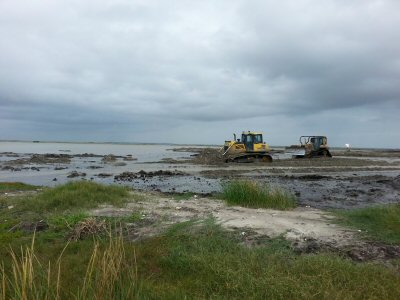 |
| Heavy machinery moves around sediment that has been piped in from the Mississippi River at a coastal restoration project in Plaquemines Parish in November 2013. © Amy Wold, The (Baton Rouge) Advocate |
For many years, the only dedicated funding for coastal restoration work was the Coastal Wetlands Planning, Protection and Restoration Act (CWPPRA), passed in 1990, which allocated a certain amount of money in the millions every year for coastal restoration in Louisiana. The money is allocated by a task force made up of representatives from five federal agencies and one state representative.
CWPPRA (pronounced quip-ra) is still in force, but has been joined by various other funding mechanisms.
Things changed in the wake of Hurricane Katrina and Hurricane Rita in 2005. A number of reports were done about what went wrong during the disaster around the metro New Orleans area — including reports by the the U.S. Army Corps of Engineers' Interagency Performance Evaluation Task Force and the Independent Levee Investigation Team. Links to many of those reports can be found here.
One of the findings was that levee systems protecting areas like New Orleans were systems in name only. The state also recognized that the separate arms of coastal restoration and levee protection needed to be better integrated, which led to the formation of the Coastal Protection and Restoration Authority (CPRA).
This authority brought in the coastal restoration focus that had been within the state Department of Natural Resources and levee functions that had been within the state Department of Transportation and Development, as well as other agencies, to form a new organization. As such, this CPRA put together its first master plan in 2007, which focused on what the state should do for coastal restoration and flood risk reduction, acknowledging that the two are connected.
One example of the connection is that, as land loss continues, some flood-risk-reduction levees that were initially buffered by expanses of wetlands are now exposed to large wave action. Some levee districts have taken to rebuilding marshes outside their levees to help protect the infrastructure.
This master plan was fairly general in nature, but as the law creating CPRA required, the organization released a five-year update in 2012. This updated plan was much more specific and spelled out a 50-year, $50-billion vision that state planners hope can stabilize the coast.
Work has already started on the next five-year update and it will be released in 2017.
Economic issues
There are a number of studies that have come out (especially over the last five years) that look at the economic impact of coastal restoration on the state and the nation. There's this one from a Tulane University economist: "The Economic Impact Of Coastal Restoration And Hurricane Protection."
And this one from Center for American Progress and Oxfam America.
And this one from the Louisiana Workforce Commission.
There are many, many others and all seem to point to the economic possibilities that not only direct work on coastal restoration can have, but also the long-term possibilities as Louisiana scientists generate expertise that could be used in other areas of the country or world as sea-level rise continues.
Diversion
One of the projects moving forward now would divert water and sediment from the Mississippi River to the wetlands in the area of Myrtle Grove in Plaquemines Parish. Although there have been previous diversions at Davis Pond and Caernarvon, this is the first diversion with a goal of moving as much sediment into the marshes as possible. To help inform the design of this project, the state and the Corps are working on the Mississippi River Hydrodynamic and Delta Management Study to get a better handle on what sediment is in the river and how that sediment moves through the river.
Some work on this has been done with researchers looking at the decrease of total sediment in the river and, more recently, researchers looking at the steady supply of sand into the river.
As this diversion at Myrtle Grove gets closer to being a reality, there have been very vocal concerns about what that amount of freshwater will do to the fisheries in the area. Some fishermen say it will be beneficial, others say it will collapse the system. The main group organizing a push-back against large river diversions comes from The Save Louisiana Coalition.
State officials and others say that it won’t collapse the fishery but it will move things around. However, as land loss continues, those fishing areas would change anyway. Sea Grant has this fact sheet on possible impacts.
In response to concerns, the CPRA, through the nonprofit The Water Institute of the Gulf, has set up an expert panel on diversions to help address some of the questions that remain on how such a diversion should be designed and operated.
BP disaster aftermath
On April 20, 2010 British Petroleum’s Deepwater Horizon oil rig exploded in the Gulf of Mexico, killing 11 and spilling an estimated 4.9 million barrels of oil. It took 87 days for the well to be capped and oil, mainly in the form of tarballs, continues to wash onto Louisiana’s coastline. Unlike other states, most of Louisiana’s coastline is made up of marshes, not sandy beaches, so the oil cleanup was difficult if not impossible in some of these areas. Although there were attempts, the Coast Guard determined that many areas of interior marsh would be more damaged through cleanup efforts than if the oil was left to break down through natural means.
You’ll find lots of information about the response, cleanup and decisions here on the federal response website.
The Deepwater Horizon disaster kicked off the Natural Resource Damage Assessment process which uses science to determine what damage an oil spill caused and then puts a dollar figure on how much it will cost to repair that damage.
Those studies are ongoing, and many are not public because of legal actions pending.
This is another good site for research information from the Gulf of Mexico Research Initiative, funded through a financial commitment from BP to pay for independent research on the impact of the oil spill.
Some study results have been released and they show possible problems that could manifest in the future. NOAA released a report in March that showed large marine fish like bluefin tuna developed heart and other defects when fish larva were exposed to Deepwater Horizon oil.
Similar exposures led to genetic issues in baitfish like the Gulf killifish: Environmental Science & Technology or National Science Foundation.
A study of dolphins in Barataria Bay, an area hit hard by the Deepwater Horizon oil, found that many of the animals were in poor condition.
Researchers at LSU and across the Gulf have also found impacts on land, ranging from increased land loss as the oil killed marsh which was holding soil in place to impacts on insect colonies living in that marsh.
This research is part of a larger work looking at various impacts across the Louisiana coast.
Most biologists say that it will be a number of years before there is enough information to determine what lasting impacts the oil could have on the ecology and biology of Louisiana’s coast. In the meantime, the NRDA process on trying to determine damage continues, and it could be several years before that legal issue is settled.
BP Settlements and the RESTORE Act
As a type of down payment on an eventual NRDA settlement, BP agreed to put forward $1 billion for early restoration projects. A link to that process and the projects that have been approved so far is here.
In addition, there is the RESTORE Act, which will dedicate a large portion of administrative and civil penalties to a Gulf Coast Restoration Trust Fund to be divided among the five Gulf states in a variety of ways.
There is funding available through Deepwater Horizon settlements that allocated money to the National Fish and Wildlife Foundation to be divided as well. In Louisiana, the money goes toward barrier island restoration and river diversions.
In early May 2014, Tulane University and the Environmental Law Institute released a white paper that does a really good job of outlining all of the funding sources that could come out of the Deepwater Horizon disaster, what they are slated to pay for and how that money is distributed.
The white paper also looks at how these funding mechanisms could overlap in good or sometimes redundant ways, with many good graphs. As all this work continues, and the consequences of the 2010 oil spill continue to unfold, the state and a number of organizations work to increase the awareness of why protecting and stabilizing Louisiana’s coastline is not just a local issue, but a national one.
Five of the 15 largest ports (by tonnage) in the United States are in Louisiana. The state provides a large amount of oil and gas infrastructure and productions as well as the habitat to produce great fisheries.
A more detailed listing is located here.
There has long been a recognition of the costs and benefits of a fully protective river levee system. Here’s an amazing excerpt from the National Geographic issue of December 1897 (the date is not a typo): “No doubt the great benefit to the present and two or three following generations accruing from a complete system of absolutely protective levees, excluding the flood waters entirely from the great areas of the lower delta country, far outweighs the disadvantages to future generations from the subsidence of the Gulf delta lands below the level of the sea and their gradual abandonment due to this cause. While it would be generally conceded that the present generations should not be selfish, yet it is safe to say that the development of the delta country during the twentieth century by a fully protective levee system, at whatever cost to the riparian states and the Federal Government, will be so remarkable that people of the whole United States can well afford, when the time comes, to build a protective levee against the Gulf waters, as the city of New Orleans has done on a small scale against the sea water of Lake Pontchartrain.”
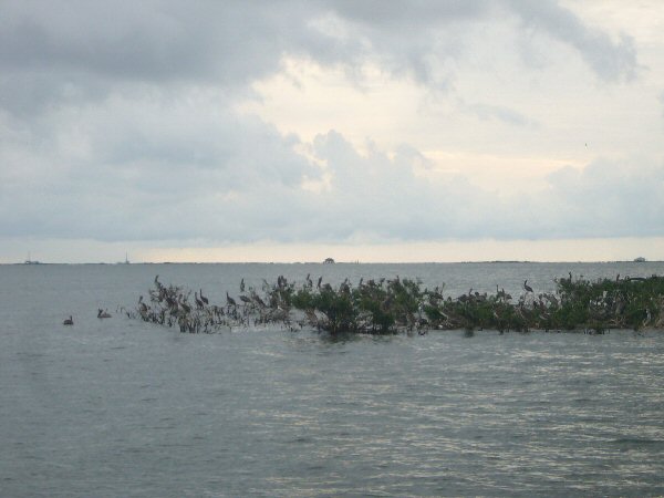 |
|
Advocate reporter Amy Wold took the above photo of the rapidly disappearing Cat Island in Barataria Basin in south Louisiana in 2012. She returned there recently and there is barely any land left above water. © Amy Wold, The (Baton Rouge) Advocate |
SEJ Publication Types:
Topics on the Beat:
Visibility:

